
Climate change is directly affecting the resilience of regional transport systems. The increasing frequency and intensity of extreme events such as floods, droughts, landslides, and heatwaves are exposing infrastructure to growing risks of degradation and service disruption.
In response to these challenges, the Région Sud – Provence-Alpes-Côte d’Azur and the French State launched an ecological planning initiative in 2023 to strengthen the sustainability and resilience of the regional transport system.
This approach is based on the ACoRS framework (Adaptation, Conversion, Modal Shift, Sobriety) and is part of a State-Region agreement aimed at developing a regional transport adaptation plan.
The objective is clear: anticipate rather than react. This requires integrating climate considerations as a core parameter in transport policies and investment decisions.
Cerema is leading a research and development study aimed at assessing the physical climate risks affecting all transport infrastructures, including road, rail, river, maritime, and airport systems.
To carry out this analysis, Cerema Méditerranée has formed a consortium of public and private stakeholders, including:
The objective goes beyond building a knowledge base. It is about producing information that can be directly used for planning, prioritizing actions, and guiding public investment decisions.
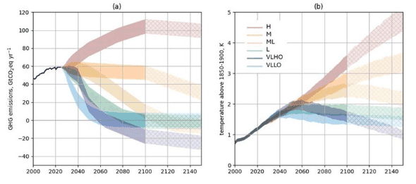
Open-source reference climate datasets (CMIP6, DRIAS, TRACC) are essential. However, they reach their limits when it comes to conducting detailed spatial analyses at the scale of local infrastructure.
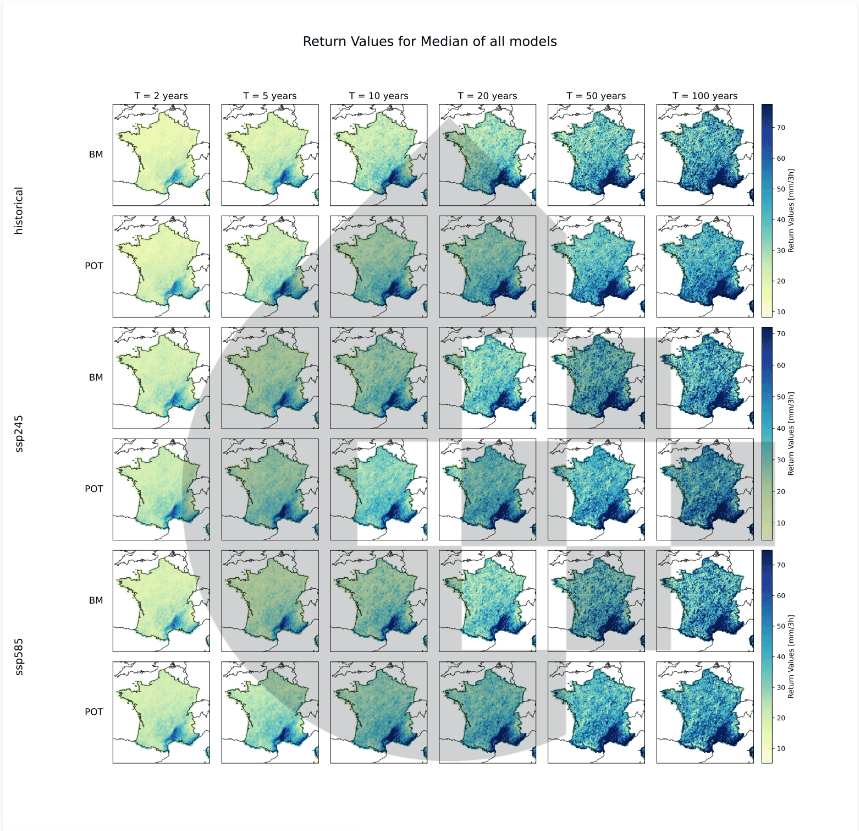
Hydroclimat has therefore developed a downscaling methodology at a 1 km² resolution, enabling:
This spatial resolution is essential to move from a regional understanding of climate to an operational analysis of transport networks.
Rather than relying on a single-threshold approach, Hydroclimat develops composite indicators that combine climate data, topography, and land use.
These indicators make it possible to:
This approach provides a more detailed and robust framework for prioritizing adaptation actions.
The analyses produced do not rely solely on climate modeling. They also incorporate operational feedback (infrastructure managers, local engineering teams) to refine degradation thresholds and assess the capacity of systems to absorb and adapt to climate hazards.
This integration of science, engineering, and operational insight is essential to deliver assessments that are both credible and truly actionable.
Hydroclimat also supports the design of reporting formats to ensure both scientific rigor and usability for a wide range of audiences, including technical teams, local authorities, and decision-makers.
Maps, dashboards, risk narratives, and transparent communication of uncertainties are developed as true decision-support tools, rather than simple technical deliverables.
Hydroclimat’s contribution to this project provides the Region and the State with:
This collaboration demonstrates that an effective transport adaptation strategy cannot rely on generic climate data or purely top-down approaches. It requires a territorially grounded adaptation science, capable of linking climate modeling, local vulnerabilities, and operational decision-making.
At Hydroclimat, we are convinced that only under these conditions can climate information become a true lever for transforming public policy, supporting more resilient territories in the face of climate change.
Transport networks are exposed to increasingly frequent and intense climate hazards (floods, heatwaves, droughts, landslides). These events can lead to infrastructure degradation, service disruptions, and higher maintenance costs.
Transport networks are mainly exposed to floods, extreme heat (rail deformation, road surface damage), droughts (soil shrink–swell), and landslides, all of which can weaken infrastructure.
Climate change increases the risk of disruptions and service outages. Extreme events can make certain infrastructures temporarily unusable, affecting user mobility and economic activities.
Global climate datasets (CMIP6, DRIAS) often lack the spatial resolution needed to assess impacts at the local scale. Adaptation decisions require high-resolution data tailored to the specific characteristics of infrastructure.
Transport systems are essential to the economic and social functioning of territories. Their adaptation ensures service continuity, user safety, and resilience in the face of climate-related crises.

How much will climate risk really cost?
6/29/2026
CMIP 6 VS CMIP 7
5/29/2026
LSTM model: a new approach to simulating river flows
5/17/2026

Coastal flooding, a risk that insurers still underestimate as we look toward 2050
4/23/2026
Extreme precipitation remains underestimated: a key challenge for climate risk assessment
4/16/2026