Country – France
Objectives of agro-climatic projections
Agriculture, which is highly dependent on climatic conditions, is facing unprecedented upheavals related to climate change. Anticipating these impacts and providing tools to guide agronomic decisions is becoming a strategic priority. The objective of this project, carried out for Weenat, is to produce agro-climatic indicators with high spatial resolution for the French territory, in order to feed an operational tool dedicated to accompanying agricultural practices in the context of climate change.
Based on a rigorous methodology, this study combines the analysis of historical meteorological data, future projections and the generation of specific indicators. It aims to meet the needs of players in the agricultural sector to ensure the resilience of their activities.
Phase 1: Creation of a historical weather database
The first step in this agro-climatic projection is to develop a historical meteorological database with high spatial resolution for the French territory. This database will incorporate key variables such as temperature, precipitation, humidity and wind to provide an accurate picture of past climatic conditions. This data is used as a reference to assess future climate changes and identify trends that may influence agricultural activities.
Phase 2: Future weather forecasts
The second phase focuses on the production of a set of meteorological variables projected over a “typical year” and three future time horizons. These horizons, generally located in the short, medium and long term, make it possible to anticipate the impacts of RCP (Representative Concentration Pathways) climate scenarios on the different regions of France.
Projections include data such as the frequency and intensity of heat waves, periods of drought and frost, and rainfall variability, to identify the main challenges facing crops.
Phase 3: Production of agro-climatic indicators
Finally, the last phase consists of producing specific agro-climatic indicators, such as drought indices and critical frost periods. These indicators are crucial for farmers, as they will enable them to improve their crop cycle planning systems, optimize resources and minimize losses linked to extreme weather conditions.
A proactive approach to tomorrow's agriculture
Faced with the growing impacts of climate change, agro-climatic projections are an essential lever for anticipating future challenges and developing robust adaptation strategies. This project, conducted as part of our climate change data service, offers innovative solutions to support the agricultural sector in its transition to sustainable, resilient management. By combining a rigorous analysis of historical data, precise future climate projections and adapted agro-climatic indicators, this study provides a solid basis for ensuring the sustainability of agricultural activities, even in an uncertain climate context.
Applications and benefits of agro-climatic indicators
The results of this project are intended to feed an operational agronomic support tool, providing decision-makers and farmers with valuable information to help them adapt their practices. This tool will enable :
- Improve crop management, taking into account the specific climatic constraints of each region.
- Strengthen the resilience of farms in the face of climatic hazards by anticipating risks.
- Optimize the use of natural resources, such as water and agricultural inputs, for more sustainable agriculture.
These indicators will also help guide public policies on agriculture and regional planning, by identifying the areas most vulnerable to climate change.
How to understand agro-climatic projections?
Agro-climate projections are the analysis and modelling of meteorological and climatic data to produce indicators adapted to agricultural specificities. These indicators are designed to address the challenges posed by phenomena such as rainfall variability, rising temperatures, periods of frost or intensified droughts.
Thanks to their high spatial resolution (1 km), the results of this study offer unrivalled precision, enabling direct application on a local scale. This level of detail is essential for guiding agronomic practices and developing targeted adaptation strategies for each region.
Example of rendering:

Why make agro-climatic projections
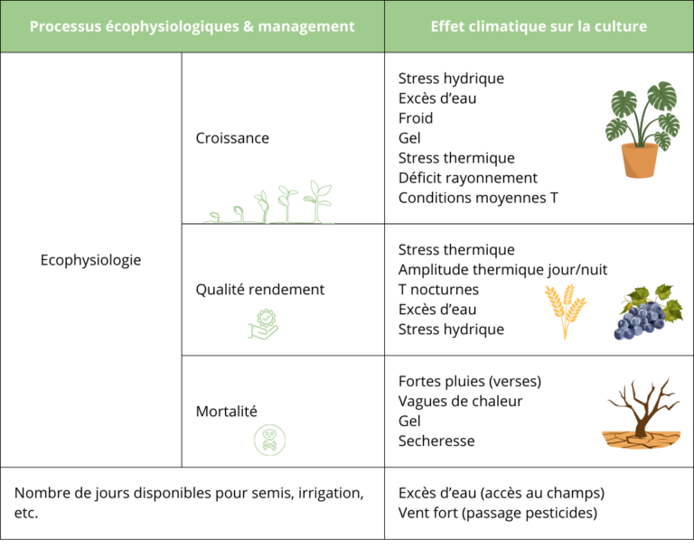
Agro-climatic projections offer an essential vision for understanding the effects of climate change on crops and adapting farming practices accordingly. The main impacts identified can be structured around plant ecophysiological processes or constraints linked to agricultural management.
The effects of agro-climatic conditions on crop growth
Plant growth is directly influenced by variations in climatic conditions. Agro-climatic projections highlight several stress factors likely to impact this process. Among these is water stress. A lack of water reduces plants’ ability to photosynthesize, thus limiting their development. Conversely, excess water saturates the soil, preventing roots from breathing properly and increasing the risk of disease.
Other phenomena such as cold and frost slow growth, particularly at the beginning or end of the season, causing delays in vegetative cycles. Periods of heat stress, linked to excessively high temperatures, disrupt plants’ essential metabolic functions. In addition, a lack of solar radiation, often caused by prolonged cloudy episodes, reduces the energy available for photosynthesis. Finally, average temperature conditions, when they deviate from normal values, have a lasting effect on crop growth and development cycles.
Increased risk to crop survival
Beyond growth and yield, agro-climatic projections highlight the increased risks to crop survival in the face of extreme conditions. Visit heavy rains or heat waves are a direct threat to crops. Similarly, the frost, particularly during the flowering period, and drought. reduce plants’ ability to draw on the resources they need to survive. It is therefore necessary to strengthen and reorganize agricultural practices to increase productivity and crop resilience (adaptation) in a sustainable way to climate change.
Managing agricultural operations in the face of agro-climatic constraints
Agro-climatic conditions influence farm management practices. the number of days available for sowing, irrigation or crop maintenance can be reduced by episodes of excess watermaking the fields inaccessible. Strong winds, often associated with climatic disturbances, complicate operations such as pesticide or fertilizer application.