Extreme precipitation is currently systematically underestimated by global climate models.
Estimating extreme precipitation at fine spatial (kilometric) and temporal (sub-daily) scales is a critical challenge for climate risk assessment. Yet this task remains constrained by several methodological limitations.
Global climate models (CMIP6), which are essential for projecting future climate change, operate at relatively coarse spatial resolutions. At these scales, they cannot accurately represent convective processes, orographic effects, or the spatio-temporal intermittency of extreme events. They also struggle to capture local intensity hotspots, where the most severe precipitation events are concentrated.
As a result, extreme precipitation intensities are systematically smoothed and attenuated, while spatial gradients are poorly represented. This limitation can lead to the dilution or even disappearance of critical hotspots within climate datasets.
This bias is particularly problematic because it is precisely these extreme events and their locations that drive hydrological impacts and shape climate risk levels.
One way to address this bias is to use kilometer-scale regional climate models capable of explicitly resolving deep convection, known as Convection-Permitting Regional Climate Models (CP-RCMs).
For example, Météo-France's CNRM-AROME model (approximately 2.5 km horizontal resolution with 60 vertical levels) incorporates state-of-the-art numerical weather prediction capabilities, including:
These models provide significant benefits for applications such as convective storm tracking, urban climate studies, and complex environments like mountainous regions.
However, they remain extremely computationally expensive, which strongly limits their large-scale operational deployment.
In this context, Colas Droin, Adrien Lambert, Morgane Terrier, and Magali Troin presented an innovative statistical approach at EGU 2026. Rather than recalculating the climate at high resolution, their method reconstructs high-resolution extreme precipitation patterns from coarse climate datasets while preserving the large-scale climate signal.
The idea is to explicitly correct what is lost during the scaling process by leveraging an existing concept: Areal Reduction Factors (ARFs). In this framework, ARFs are repurposed from their traditional use and transformed into a true scale-transition operator between climate resolutions.
Traditionally, Areal Reduction Factors (ARFs) are used to relate point rainfall intensities to area-averaged precipitation values. In this new approach, they are reformulated as a tool for transitioning between climate model resolutions.
The methodology is based on comparing extreme precipitation return levels derived from datasets with:
This comparison quantifies the attenuation of extremes induced by spatial resolution. The resulting ratios are interpreted as spatially distributed ARF fields, characterizing the loss of intensity associated with coarser grid cells.
These ARF fields are then applied as multiplicative correction factors to adjust low-resolution climate outputs.
This approach produces:
The methodology is evaluated using independent rain gauge observations and subsequently applied to climate projections to assess its robustness under future climate conditions.
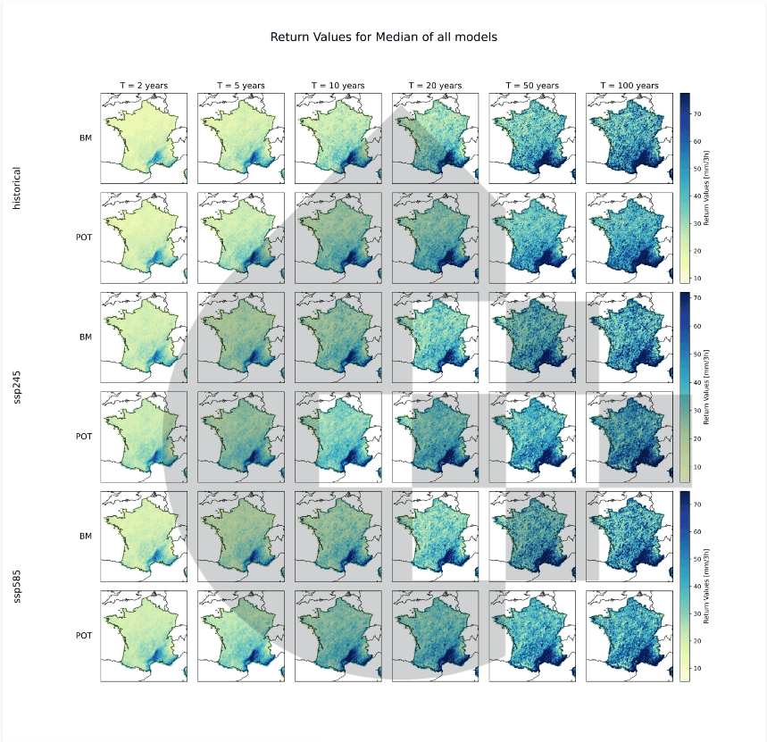
It enables the production of high-resolution (1 km), sub-daily (3-hour) extreme precipitation intensities for both historical and future periods. These outputs provide climate risk indicators that can be directly integrated into decision-making processes.
In practice, this type of information offers significant value for:
Beyond simply increasing resolution, these data support concrete decisions such as infrastructure sizing, hazard mapping, and the development of climate adaptation strategies.
This research highlights that the challenge is not only access to climate data, but also the ability of those data to represent climate processes at scales relevant to impacts.
For many years, climate analyses have relied on models that spatially smooth the climate signal, leading to an averaged representation of risk. However, impacts are often driven by localized and extreme phenomena whose dynamics are largely lost at coarse resolutions.
This approach offers a new perspective: restoring extreme events where they actually occur while maintaining consistency with large-scale climate dynamics.
It paves the way for the production of spatially resolved hazard metrics that are statistically robust and consistent with future climate trajectories without requiring computationally intensive numerical simulations.
This represents a significant step toward high-resolution, reliable climate data that can be directly used to support climate risk assessment, infrastructure planning, and adaptation decision-making.
Global climate models such as those used in CMIP6 operate at relatively coarse spatial resolutions. They struggle to accurately represent local processes such as convective storms, topographic effects, and strong spatial variability in precipitation patterns. As a result, extreme rainfall events are often underestimated, and the areas most exposed to flood risk may be poorly represented.
Climate downscaling is the process of transforming low-resolution climate projections into finer-scale data suitable for local analyses. This approach makes it possible to estimate extreme precipitation at kilometer-scale resolution while preserving consistency with large-scale climate scenarios. It is particularly valuable for climate risk assessment, hydrological modelling, flood risk analysis, and climate adaptation planning.
High-resolution climate data makes it possible to identify extreme precipitation hotspots that may be overlooked by conventional climate models. It improves hazard mapping, hydraulic infrastructure design, insurance risk assessment, and climate adaptation planning for local authorities, infrastructure operators, and water resource managers. By providing a more detailed representation of climate hazards, 1 km resolution data supports more informed and effective decision-making.

Adapting Regional Transport Networks to Climate Change: From Assessment to Action
9/3/2026
CMIP 6 VS CMIP 7
5/29/2026
LSTM model: a new approach to simulating river flows
5/17/2026

Coastal flooding, a risk that insurers still underestimate as we look toward 2050
4/23/2026

A methodological breakthrough for improving extreme precipitation bias correction
3/17/2026